Tuesday, 26 May 2020

Geolocation in lockdown

Even if we must not venture much further afield than our local supermarket during our current working from home endeavours, we must remember that BGS holds specimens in the National Geological Repository which come from all over the UK, and in fact the world.

We've discussed the value of attaching numerical points to our older specimens in one of our sister blogs (here and here), but put simply, adding geospatial data to the specimen record gives it another way to interoperate with our other systems, for example our GeoIndex. That means another way for researchers to find the critical specimen that they are looking for to answer their questions.

With many staff finding themselves juggling their time around new ways of living and working, and each grid reference taking about five minutes to locate, this has become a useful background task for a number of people, some of whom regularly work with our collections, and others for whom it is a new thing. Each location "solved" is another piece of the massive geolocation jigsaw put into the right place.

Points mean progress! Over 2000 new locations have been added to this dataset just in the last few
weeks, and the rate is increasing. (Map made in QGIS, basemap © OpenStreetMap contributors)

Without access to professional grade mapping in our GIS systems at work, ingenuity has been the order of the day but we are still able to produce professional quality results. Our "mashed-up" system includes:
  • Training has been provided via video conferencing and screensharing. After the first couple of live performances, this was recorded and can be reviewed whenever extra training is needed
  • Many of our internal resources, which can be accessed over secure VPN
  • Several excellent sources of open geospatial data, including Ordnance Survey Open Data, GB1900 project, National Library of Scotland Maps, and many more
  • Data cleansing and processing in QGIS
  • Regular automated polling of the data being inputted to plot live progress maps (like the above) and reports:
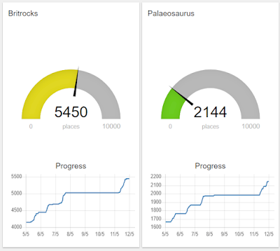
Friendly competition? To be fair, one of the teams started work a few weeks before the other!
So far we have been working on locations in England, Wales and Scotland, as they all fall under the OSGB36 co-ordinate system but with only minor modifications, and retraining, the rest of the world is easily in our capability. 

Andy Freeman, our newest curating technician, has been working on the project, and found that it tied in nicely with his interest in history and walking:

"Since starting home working I have been working almost exclusively on BritRocks finding grid references for samples that were collected before the introduction of the OS National Grid. To do this I look at the locality description of the sample and then use the National Library of Scotland’s georeferenced maps to find it. Being somewhat of a history geek and a major map geek searching historical maps is right down my street! There were around 8000 samples that needed a grid reference and in-between finding samples I have also been retracing my past steps in some of the high places like Skiddaw, Cadair Idris and Snowdon; and finding that the routes I took are very old indeed. I grid referenced a lot of samples from the Charnwood area which as you will know is very local to us and was very enjoyable. I even found out that the place in Cotgrave Woods I grew up to know as “the bomb drop” and my dad grew up to know as “devil's drop” was in fact a medieval quarry. So all in all I have very much enjoyed this work during a very strange time."

Look out for these enhancements coming to a dataset near you soon!


Monday, 11 May 2020

Working from home - turning problems into solutions

In the core store at BGS, we are heavily reliant on our team of three technicians. They take our incoming material in the form of core, cuttings or other samples, and enter it onto our database, and then store the material in our core store where it can be accessed by visiting researchers. If you've ever visited the BGS core store, then the material you looked at will have been laid out on the examination benches by one of them.

The sudden onset of lockdown at the end of March meant that progress on all of these activities ceased, practically overnight. Fortunately, we had a long list of "back-burner" activities that we were able to bring up. Many of our staff were also generous enough to volunteer the loan of their own IT equipment amidst a global laptop shortage.

Here, Neil Stacey, one of our Curating Technicians, shares his home working setup:


"In the photo, you can see:

  • Personal Apple Mac version 10.6 using 17” screen for Excel .xls data input
  • Personal 9” iPad for viewing and downloading marine images
  • Personal clock to see how much time spent on data input
  • Personal ruler for measuring how long I have been inputting data(!)
  • Personal phone to order takeaways...

We loaded a number of photographs of pallets of our Marine samples onto ShareFile (our corporate filesharing platform), which I was then able to download to my iPad. Working from home I have been able to extract handwritten data on the ends of the boxes into an Excel spreadsheet. This has included:


There can be a lot of data trapped in handwritten annotations

  • 26,000 marine sample locations, almost all matched to existing barcode data
  • 5,000 miscellaneous borehole entries
  • 497 Hydrographic Office samples
  • 146 Entries relating to the Falkland Isles
  • 2,180 Shallow commercial UK continental shelf samples

So in a few short weeks of lockdown, I have been able to enhance the data we hold on about thirty  three thousand items in our collection."

As life begins to return to normal, we will import this into our corporate database, where it will be extremely useful and will really improve the day to day operation of our marine samples collection.

Thank you, Neil!

Friday, 1 May 2020

3D scanning our collections

Today, more than ever before, it is vital that we find new ways of sharing our collections in the virtual world, as well as the physical one. This post is the first in a series of posts showing ways in which you can access the BGS collections from the comfort of your own home or office.

The collections team has recently taken delivery of a new tool to help us in the digitisation of our collection. An Artec Space Spider joins our existing NextEngine laser scanners which we use to create 3D models of objects. Compared to the older hardware, our new scanner expands our capabilities greatly:
  • It's portable. Combined with a laptop this allows us to head into the stores and scan some of our larger items without having to move them far from their cabinets.
Scanning a large ammonite in the BGS core store
  • It's quicker. Scans of typical "hand specimen" sized objects now take around 15 minutes rather than the hour or more that it previously took.
  • Better detail. Typical scanning resolution is between 0.1 and 0.3mm which means that even fine details are visible in fossils. And we can apply a colour layer to the scan surface to accurately reflect the appearance of the original object.

Processing the scanned data

So how does this look in practice? Tom, a geology student at the University of Leicester, volunteered with us for several months, in between his studies. In that time, he undertook to scan representative examples of zonal ammonites in our collection.

These species are very important because they allow correlation of the relative ages of rock layers between different locations, so wherever in the world you find a given zonal species, you can be sure that you are looking at rocks of the same age. For example, geologists in the field would look for the first occurrence of the ammonite Psiloceras planorbis to mark the very start of the Jurassic period, although the situation is actually a little more complicated…

Tom scanned the ammonites using both our NextEngine and Spider scanners, with colour texturing turned off so that differences in the preservation of the specimens would not affect the perception of form of the fossils. He then uploaded them to Sketchfab, where they can be viewed in a web browser.

Comparing Lower Jurassic Zonal Ammonites
So the next time you're in the field, and can't remember your obtusum from your oxynoticeras, then load up our virtual collection at https://sketchfab.com/3dFossils/collections/jurassic-zonal-ammonites to make sure.

GSM 24881 Pleuroceras Ammonite 500K

Simon Harris
Collections Conservation and Digitisation Manager

Monday, 10 February 2020

Francis Redfern Blog

Francis Redfern, Cooper, Historian, Antiquarian, Artist, Poet, Diarist and Geologist 

Francis Redfern

The 19th century was a time when many an aspiring gentleman sought to improve his status in life through the pursuing of worthwhile hobbies and pastimes. One prime example of this was Francis Redfern.  Born in Fenny Bentley, near Ashbourne, in Derbyshire in 1823 he was the oldest of 10 children.  His father was the landlord of the Bluebell Inn. Francis received limited formal schooling in nearby Tissington, his school master John Smith, leaving a lasting impression on his life.  At the age of 15 he was apprenticed to a Cooper, Samuel Brassington, in Uttoxeter in Staffordshire.  At the time Uttoxeter was an important, but waning market town that the Industrial Revolution had passed by.  After completing his apprenticeship Francis purchased his own coopering business in Carter Street, supplying barrels for the transportation of both wet and dry goods.

In his spare time Francis indulged his interests and curiosities trying to record the history Uttoxeter.  Despite the town having a rich history stretching back to the early medieval period it had never been formally recorded.  Francis set out to change this: his work, The History and Antiquities of Uttoxeter and Neighbourhood, first published in 1857, encompassed the history of the town from ancient times to the present day.  During his investigations Francis studied the geology of the area around Uttoxeter to determine its origins and what was there before recorded human settlement, concluding that, “Uttoxeter is situated upon what is geologically termed the drift formation, which belongs to the upper tertiary epoch and immediately beneath the materials of the alluvium.”

Whilst conducting his research Francis was able to carry out fieldwork on geological formations that had been unearthed during work on the outer edge of the town to try to determine their origins.  Francis had access to only basic tools to help him determine details about the formations he was examining, often relying on chance discoveries made by others.


Today Francis’ home has been turned into a museum that continues to tell the story of Uttoxeter and its residents.  The exhibition display on Francis Redfern features geologist’s tools including a geologist’s hammer, a clinometer and a geological compass, all tools that would have been familiar to Francis during his time recording local geological formations.  These tools along with fossil samples have been kindly loaned by The British Geological Survey.


Guest blog by Gordon Collins, Curator - Uttoxeter Heritage Trust.

The National Geological Repository, BGS, is happy to loan specimens for secure public display in museums, galleries and similar facilities.

Solving stratigraphic problems

Andrew Taylor, Skolithos Limited

I am a consultant geologist working on stratigraphic problems, and so spend time looking at and sampling core and cuttings stored in the BGS in Nottingham. 

This is an excellent facility where material can be recovered from storage and laid out very efficiently.  I’ve recently started to use the BGS online database, which once you understand the pathways is a great resource. 

Go to www.bgs.ac.uk/services/ngdc which is the National Geological Data Centre and follow the links to deposited data and use the advanced search to type in a well you are interested in.  The available reports are listed and can be downloaded or requested. This saves both time and money as it enables a quick review of the existing public domain data (in my case biostratigraphic reports) so that duplicating the analysis and unnecessarily sampling of precious rock, can be avoided. Instead I can either spend the budget on sections not previously studied or hand the money back to the client.  Everybody wins.

Guest Blog by Andrew Taylor, Skolithos Limited