We've discussed the value of attaching numerical points to our older specimens in one of our sister blogs (here and here), but put simply, adding geospatial data to the specimen record gives it another way to interoperate with our other systems, for example our GeoIndex. That means another way for researchers to find the critical specimen that they are looking for to answer their questions.
With many staff finding themselves juggling their time around new ways of living and working, and each grid reference taking about five minutes to locate, this has become a useful background task for a number of people, some of whom regularly work with our collections, and others for whom it is a new thing. Each location "solved" is another piece of the massive geolocation jigsaw put into the right place.
 |
| Points mean progress! Over 2000 new locations have been added to this dataset just in the last few weeks, and the rate is increasing. (Map made in QGIS, basemap © OpenStreetMap contributors) |
Without access to professional grade mapping in our GIS systems at work, ingenuity has been the order of the day but we are still able to produce professional quality results. Our "mashed-up" system includes:
- Training has been provided via video conferencing and screensharing. After the first couple of live performances, this was recorded and can be reviewed whenever extra training is needed
- Many of our internal resources, which can be accessed over secure VPN
- Several excellent sources of open geospatial data, including Ordnance Survey Open Data, GB1900 project, National Library of Scotland Maps, and many more
- Data cleansing and processing in QGIS
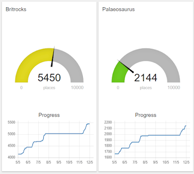
- Regular automated polling of the data being inputted to plot live progress maps (like the above) and reports:
 |
| Friendly competition? To be fair, one of the teams started work a few weeks before the other! |
So far we have been working on locations in England, Wales and Scotland, as they all fall under the OSGB36 co-ordinate system but with only minor modifications, and retraining, the rest of the world is easily in our capability.
Andy Freeman, our newest curating technician, has been working on the project, and found that it tied in nicely with his interest in history and walking:
"Since starting home working I have been working almost exclusively on BritRocks finding grid references for samples that were collected before the introduction of the OS National Grid. To do this I look at the locality description of the sample and then use the National Library of Scotland’s georeferenced maps to find it. Being somewhat of a history geek and a major map geek searching historical maps is right down my street! There were around 8000 samples that needed a grid reference and in-between finding samples I have also been retracing my past steps in some of the high places like Skiddaw, Cadair Idris and Snowdon; and finding that the routes I took are very old indeed. I grid referenced a lot of samples from the Charnwood area which as you will know is very local to us and was very enjoyable. I even found out that the place in Cotgrave Woods I grew up to know as “the bomb drop” and my dad grew up to know as “devil's drop” was in fact a medieval quarry. So all in all I have very much enjoyed this work during a very strange time."
Look out for these enhancements coming to a dataset near you soon!


